obstacle avoidancE - Medium scale

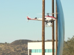
This project demonstrated the fastest low-level flight of a UAS in unmapped terrain, passing 40 km/hr while simultaneously detecting and avoid obstacles such as buildings and wires. The image below shows the vehicle autonomously flying between poles 10 meters apart.
We developed this capability in support of the DARPA OAV II program. Perception and path planning were key requirements for the planned UAS, which was expected to operate in wartime urban environments.
The 30kg payload flew on a Yamaha RMax helicopter, a 4-meter industrial UAS designed for crop dusting. Our system used a unique 3-dimensional scan-pattern LADAR capable of detecting obstacles at 300 meters distance, and wires at up to 90 meters. Our system coupled these measurements with GPS/INS measurements to produce a global map of obstacles. It intelligently planned routes in real time through detected terrain to reach sparse GPS goal points. This “set and forget” capability allowed an operator to designate a general location for the helicopter to fly to, confident that it will arrive without colliding with the environment.
We demonstrated the system in over 1000 test runs at a test facility in Phoenix AZ, and at the US Army McKenna MOUT site at Ft Benning, GA.
Publications:
Flying Fast and Low Among Obstacles: Methodology and Experiments
Sebastian Scherer, Sanjiv Singh, Lyle J. Chamberlain, and Mike Elgersma
The International Journal of Robotics Research, Vol. 27, No 5, May, 2008, pp. 549-574
Flying Fast and Low Among Obstacles
Sebastian Scherer, Sanjiv Singh, Lyle J. Chamberlain, and Srikanth Saripalli
Proceedings International Conference on Robotics and Automation, April, 2007.